
Photo Story | A Moon-Like Patch in Madagascar: Space Image Reveals 600-Million-Year-Old Rocks
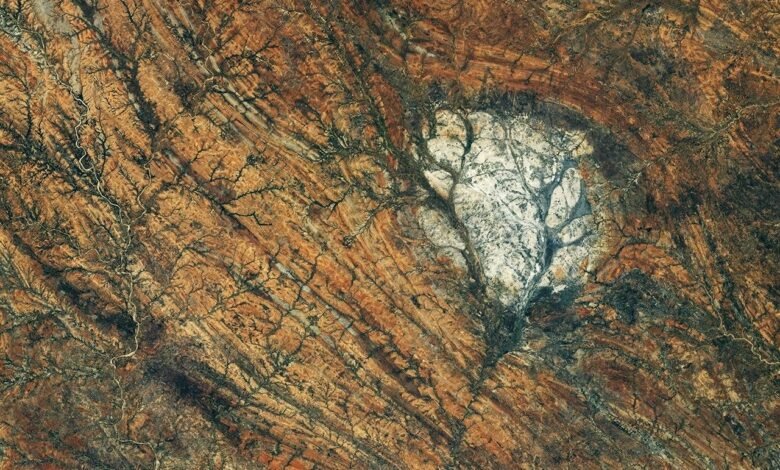
From hundreds of kilometers above Earth, a member of the International Space Station crew captured a scene that at first glance appears to be part of the Moon’s surface—but it is located in southern Madagascar. The image, selected by NASA today, October 5, 2026, as an Earth Observatory image, reveals a bright, highly contrasting rock formation amid orange and brown terrain—a scene that combines visual beauty with a geological story spanning hundreds of millions of years.
What appears in the image?
The image shows the Saririaky massif, composed of anorthosite rocks in southern Madagascar. Anorthosite is an intrusive igneous rock formed when magma cools beneath Earth’s surface, and it is characterized by large mineral crystals and a light color. According to NASA’s Earth Observatory, the formation visible in the image most likely developed in the late Precambrian, at least 600 million years ago, while its current exposure covers an area of approximately 100 square kilometers.
The comparison to the Moon is not merely visual. Anorthosite is common in the lunar crust, and areas rich in it appear from space as bright, elevated, highly reflective regions. For this reason, scientists use terrestrial examples of these rocks to help study the Moon’s early history, alongside the limited samples returned by astronauts from the Apollo program.
An image from the International Space Station
The original image was taken on August 28, 2026, by a member of Expedition 75 aboard the International Space Station, using a Nikon Z9 camera with a 400-millimeter focal-length lens. The image is numbered ISS075-E-85249. NASA explained that the image was cropped, its contrast was enhanced, and lens-related optical artifacts were removed to improve the clarity of the details.



Long rock bands running roughly from north to south appear around the white patch. Geological studies cited by the Earth Observatory indicate that the Saririaky massif lies within a ductile shear zone, where the rocks were subjected to high pressures and temperatures that reshaped them over a highly complex geological history.
When the continents were coming together
Scientists link some of this deformation to a period when the landmasses that are now Africa, India, Madagascar, Australia and Antarctica were converging as part of the formation of the supercontinent Gondwana. The image therefore tells the story not only of an individual rock, but also records the effects of continental movement and changes in the shape of Earth’s surface over immense spans of time.
The image’s value also lies in its demonstration of the scientific role of Earth observation from the International Space Station. The Earth observation program encourages astronauts to capture images of value to researchers and the public, and these images are made available through NASA’s archive for studying natural phenomena and changes on the planet’s surface.
Why does it deserve to be a photo story?
Because it brings together three worlds in a single frame: modern space photography, ancient Earth geology and a direct link to the history of the Moon. What appears from orbit as a white patch amid Madagascar’s rocks is actually a window into a story that began hundreds of millions of years ago—and that today helps us understand another world hundreds of thousands of kilometers away.
For more documented visual stories, follow Photo Story on Break Media News.
Source: NASA Earth Observatory, Image of the Day, October 5, 2026; and astronaut photograph ISS075-E-85249, the International Space Station Crew Earth Observations Facility and the Earth Science and Remote Sensing Unit at Johnson Space Center.